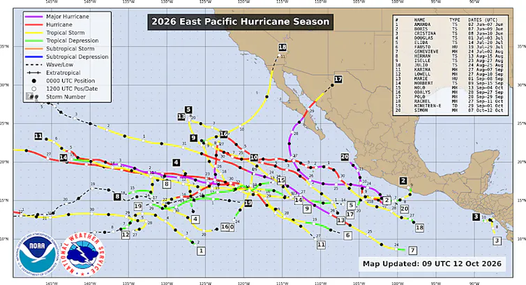
California is not a place most Americans associate with tropical weather, but it will be hit in 2026 by one of the most active hurricane seasons in the eastern Pacific in modern history.
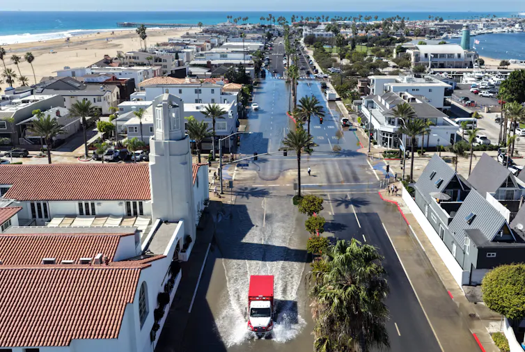
For the second time, national forecasters issued a tropical storm watch for Southern California as Tropical Storm Rachel headed toward the region, bringing high tides, coastal flooding and torrential rains October 9-11. The first tropical storm watch was issued three years earlier, for Hurricane Hilary.
The United States sometimes experiences heavy rain from the remnants of Pacific storms that pass over Mexico and spread toward the southwest United States. But the 2026 season was different. Three hurricanes flooded Hawaii as they passed near the islands, a rare event for the state. And in September, Hurricane Marie produced large waves that damaged beachfront homes near Los Angeles before moving away from the coast.
Rachel weakened to an extratropical cyclone before landfall in Baja California, but it brought strong waves to Southern California that damaged more coastal homes and flooded streets. Its rainfall flooded communities from San Diego to the desert southwest and even triggered flooding in Las Vegas.
Mario Tama/Getty Images
I study Pacific hurricanes. Although tropical storm impacts on California are unusual, they are not unprecedented. El Niño increases risks.
California’s History with Tropical Storms
Historically, Southern California has seen few direct impacts from tropical storms and many instances of damage from systems that remained offshore.
The oldest known storm here goes all the way back to 1858, when a Category 1 hurricane, known simply as the San Diego Hurricane of 1858, swept off the coast of San Diego County and brought tropical storm-force winds to the area. San Diego in the 1850s had only a fraction of today’s population, but the storm still caused significant damage.
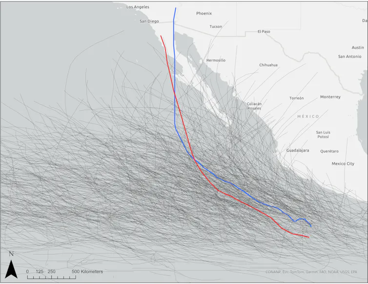
Although weaker than the 1858 hurricane, the only known tropical storm to make landfall on the California coast was a 1939 tropical storm that hit Long Beach, Los Angeles County. It brought tropical storm-force winds to a large swath of Southern California, as well as more than 4 inches of rain in some areas.
This storm came as a surprise, and the United States Weather Bureau – the forerunner of the modern National Weather Service – opened an office in Southern California in 1940 in response. A 2004 research paper hypothesized that if a similar storm hit the region in the mid-2000s, it likely would have caused more than $200 million in damage to the region.
While a few other tropical storms in the 1970s nearly made landfall in California, all weakened or changed track, avoiding a direct hit. That includes the remnants of Hurricane Hilary in 2023, which was still powerful enough to cause widespread flooding in Southern California and dump 10 inches of rain in the mountains.
A handful of additional systems that made landfall in Baja California or remained offshore brought tropical storm-force winds to the state, including Hurricane Nora in 1997.
Additionally, several recent offshore storms have generated swells that have damaged port and port infrastructure in the region, including Hurricanes Marie in 2024, Hurricane Narda in 2025, and another Marie in 2026.
El Niño increases storm risk in California
Several environmental factors increase the likelihood of tropical storms approaching Southern California.
The most notable is El Niño. This natural climate pattern, defined by unusually warm waters in the eastern tropical Pacific, increases the frequency of storms in the eastern North Pacific. Indeed, warmer than normal sea surface temperatures in the region are necessary to promote the formation and development of these storms.
NOAA
Even during El Niño years, the waters off the coasts of Southern California and northern Baja California are generally too cold to support hurricanes. However, storms moving fast enough or with enough support from upper-level winds can survive these slightly cooler temperatures, allowing the system to move closer to California.
When Tropical Storm Rachel began its approach toward Southern California on October 9, the National Hurricane Center noted that sea surface temperatures were unusually warm off the coast of Baja California and played a role in its potential to remain a tropical cyclone as it approached the coast.
The big problem with the storm: rain
Like most eastern Pacific tropical storms and hurricanes, the primary effect of these systems on California is rain.
Most of Southern California is arid and rarely receives precipitation in summer and early fall. Early reports showed Rachel dumped more than 6 inches of rain in parts of Southern California, including more than 1 inch at San Diego International Airport in one weekend. This inch of rain in San Diego is double the typical October rainfall.
While these amounts may seem tiny compared to what typically accompanies a tropical storm or hurricane in places like Florida, they can cause flash flooding in the normally dry Southwest. The National Hurricane Center warned of flash flooding in California and other areas of the Southwest ahead of Rachel’s arrival.
Unique cases like Rachel’s show that Mother Nature can always go against conventional wisdom and that, given enough time and the right conditions, potentially destructive things can happen.
Gn headline