


Central Florida continues to face widespread flooding, road closures and dangerous driving conditions as new rounds of heavy rain move through the region.
The WESH 2 First Warning Weather Team is monitoring the potential for additional precipitation Friday, with already saturated ground increasing concerns for additional flooding.
The threat will persist throughout the day, making conditions particularly dangerous in areas that have already received significant rainfall.
A flash flood warning is in effect until 12:30 p.m. for:
- Northern Brevard County
- Northern Seminole County
- South Volusia County
MORE | ROAD CLOSURES | RADAR | ACTIVE ALERTS | SANDBAG LOCATIONS | IMPACTS BY COUNTY | CLOSURE OF SCHOOLS | EVACUATIONS | SHELTERS | RAIN TOTALS
Gov. Ron DeSantis announced on social media Thursday that the Florida Division of Emergency Management was sending resources to the coast.
This includes hundreds of members of the Florida National Guard and Florida State Guard, more than 200 Florida Highway Patrol troopers and 235 Florida Fish and Wildlife Conservation Commission officers.
On Wednesday, DeSantis extended the state of emergency he declared two weeks earlier in Brevard, DeSoto, Hardee, Highlands, Indian River, Martin, St. Lucie, Glades, Hendry, Lake, Okeechobee, Palm Beach, Seminole and Volusia counties.
The amended executive order extends the state of emergency to Broward, Duval, Flagler, Miami-Dade, Monroe, Putnam and St. Johns counties.
Brightline announces closures due to flooding
Brightline announced it would suspend service in Brevard and Orange counties until Friday.
“Due to continued flooding and dangerous conditions along the rail corridor in Brevard and Orange counties, Brightline has made the decision to suspend long-haul service between Orlando and West Palm Beach for tomorrow, Friday, November 20,” Brightline said in a social media post. “The safety of our teammates and guests remains our top priority. Our crews are closely monitoring conditions as we make necessary repairs and inspections. South Florida rail service between Miami, Aventura, Fort Lauderdale, Boca Raton and West Palm Beach is operating normally.”
What to expect: day to day
The latest forecast calls for additional rainfall through Saturday, with some areas expected to receive several additional inches.
Friday is currently considered a Severe Weather Warning Day for coastal communities. The heaviest rain is expected in the afternoon.
Expect periods of heavy rain over the next 48 hours, especially in areas east of Orlando.
Sunday is expected to be mostly sunny, with only a 10% chance of rain.
Flood Monitoring
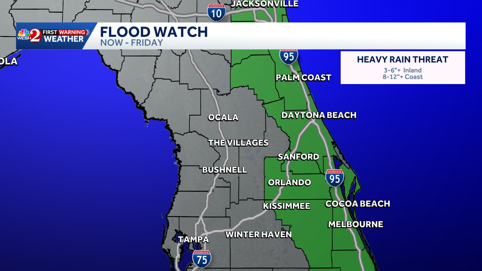
Flooding from excessive precipitation is possible across most of Central Florida, including:
- Volusia
- Seminole
- Orange
- Osceola
- Flagler
- Okeechobee
- Brevard
- Indian River
- Saint Lucia
- Martine
Recent floods
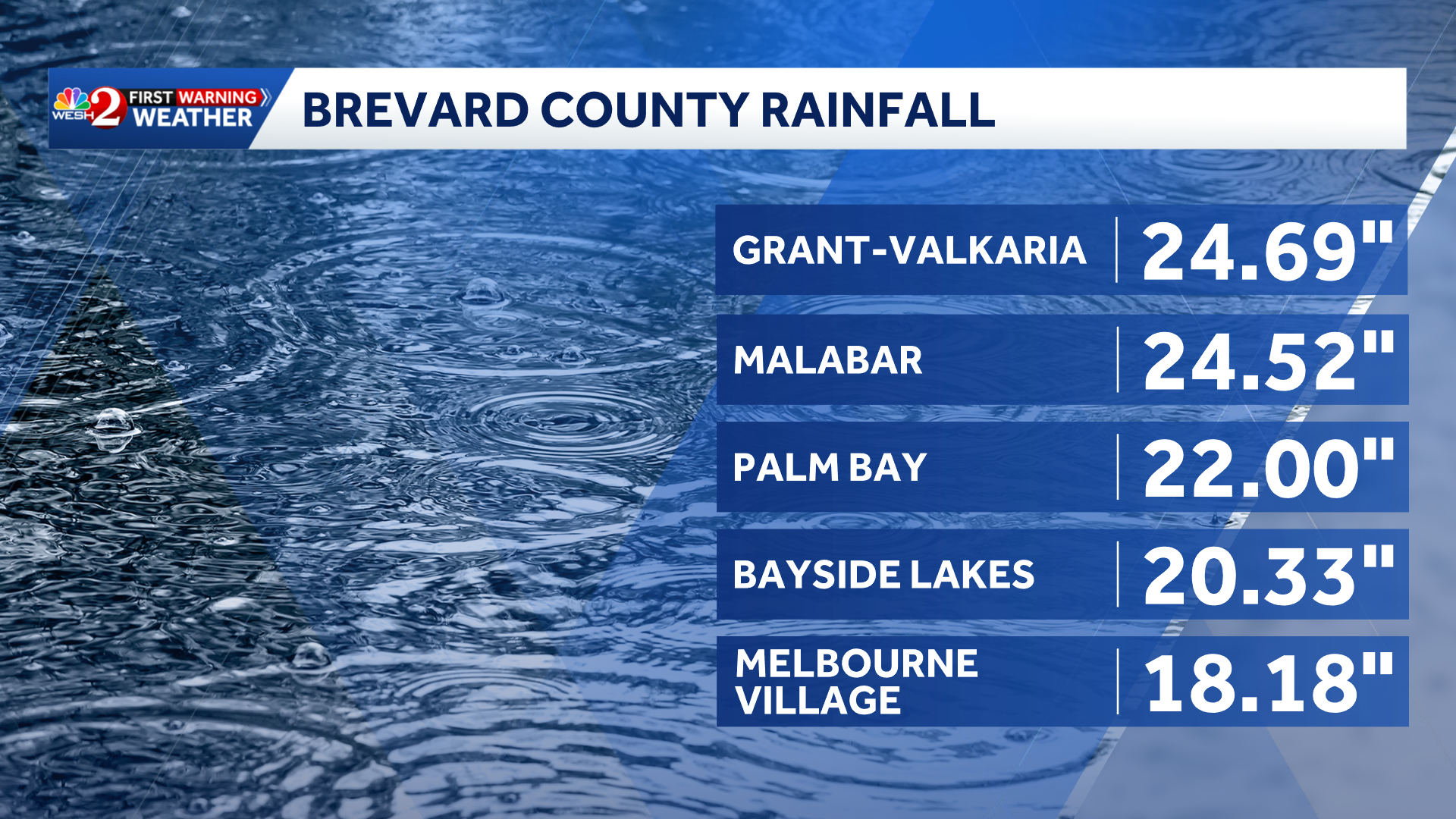
This comes two weeks after Brevard County recorded more than 20 inches of rain in some areas.
WESH 2 News
Precipitation on November 2-3 in Brevard County
Palm Bay is still struggling with the cleanup.
El Niño
Offshore tropical system
First weather alert
Stay with WESH 2 online and on-air for the most accurate weather forecasts in Central Florida.
Radar
Severe Weather Warnings
Download the WESH 2 News app to receive the most recent weather alerts.
The First Warning Weather Team includes the Chief First Warning Meteorologist Tony Mainolfi, Eric Burris, Cam Tran, Victoria Wisniewski And Luc Vickery.
Gn usa