
A combination of historic moisture from the remnants of Hurricane Polo and a plunging jet stream is bringing a widespread flood threat to the Plains and Midwest over the next few days, after already flooding the Desert Southwest earlier this week.
What makes this situation impressive
The amount of moisture in the atmosphere is expected to be near or above record levels for late September over parts of the Southwest, Texas and Oklahoma.
And tropical rain is unusual for some.

Weather in your inbox
The amount of moisture being lofted over southern Arizona, New Mexico and far west Texas is near or slightly surpassing that in the historical records. And it won’t stop as the remnants of Polo fizzle out.
“Looking back through history, heavy rains from the remnants of tropical systems are very rare across western Kansas,” wrote Jonathan Finch, meteorologist at the National Weather Service office in Dodge City, Kansas, in a forecast discussion Tuesday morning.
Happening now
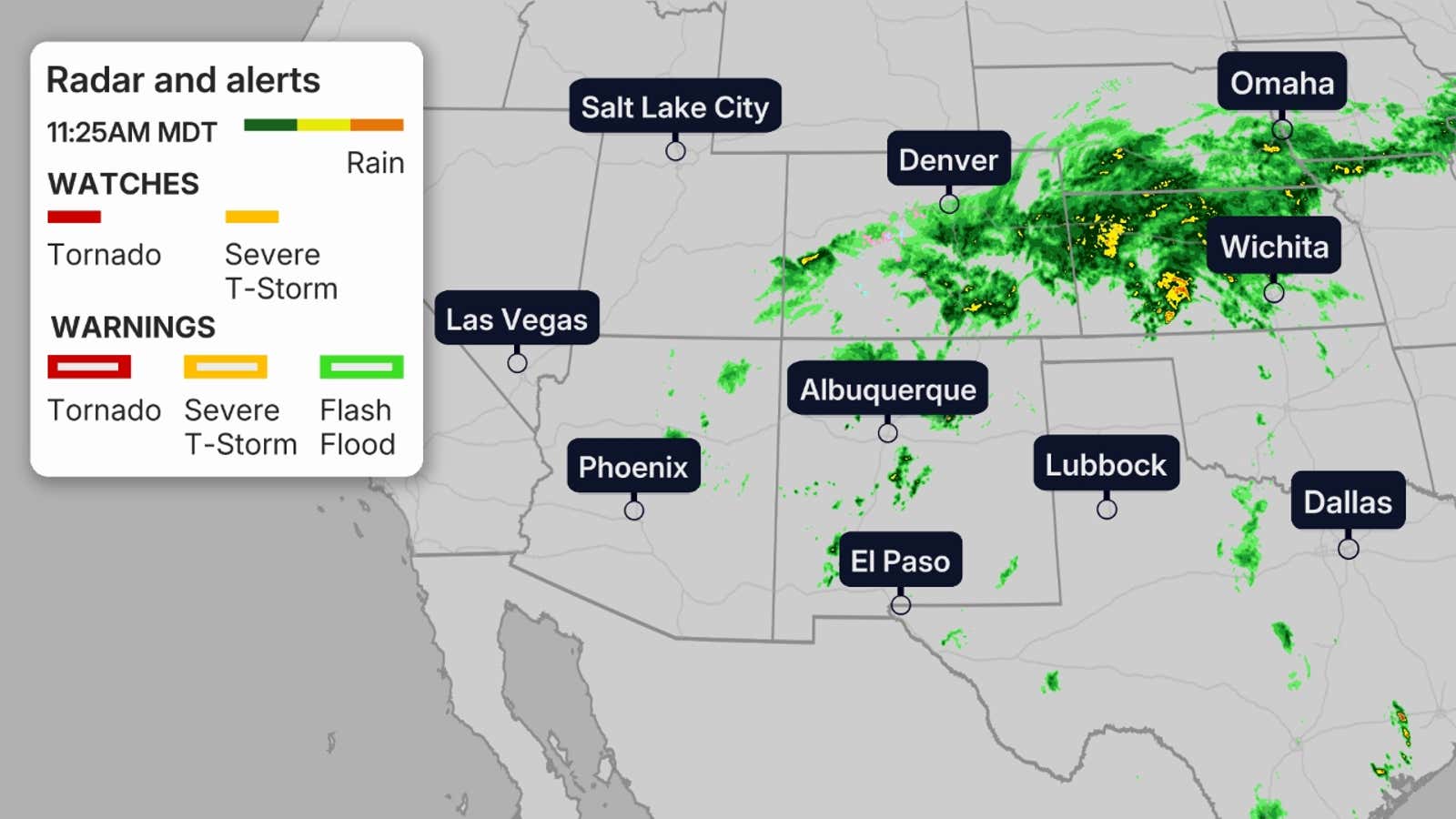
A historic plume of moisture is moving northward through northern Mexico, New Mexico and Colorado and into Texas, with rainfall rates up to 2 inches per hour. Dry washes, slot canyons, burn scars and flooded areas should be avoided.
Get More of Our News on Google
Set The Weather Company as a ‘Preferred Source’ to get quicker access to the news you value.

You can see where the rain is falling now, in the radar image below. Any watches or warnings issued are also shown on that map.
(MORE: Why flash floods hit harder in mountainous terrain)
How much rain could fall
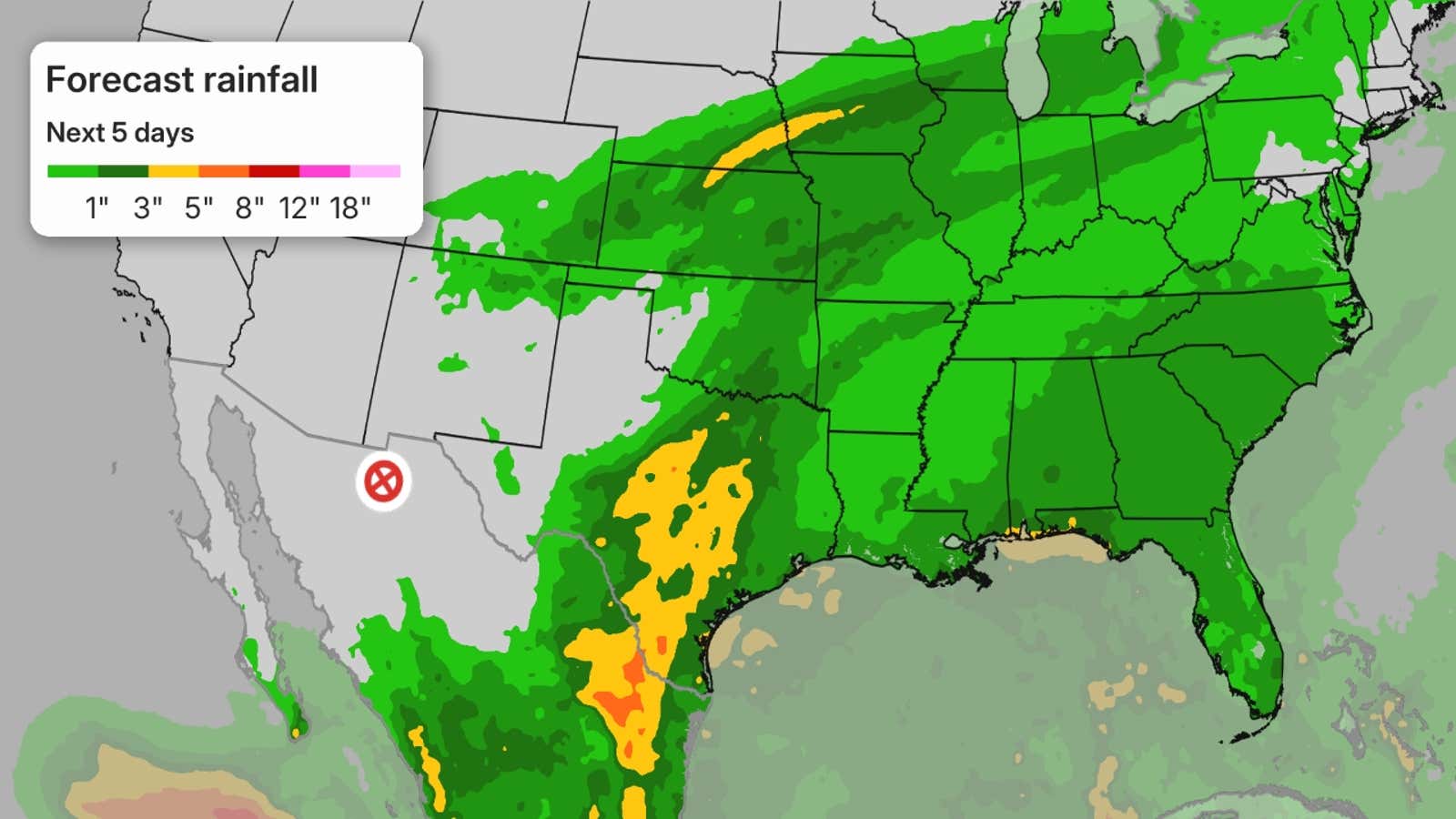
Here are the rainfall forecasts for parts of the US
- Southern Plains: 3 to 5 inches of rain, with locally higher amounts, is possible from parts of Texas into Oklahoma, including Dallas, Austin and San Antonio. This would be the heaviest rain event in eastern Oklahoma since June and in the Dallas-Fort Worth Metroplex since early July.
- Central Plains/Midwest: A strip of 3-5 inches of rain or more is expected from parts of Kansas to southern Nebraska, northern Missouri, southern Iowa and northern Illinois.
(MORE: Flooding is one of the deadliest weather events)
Flood threat timeline
The deep tropical moisture that Polo carries won’t be quick-moving, and will bring the threat for showers and thunderstorms from the Southwest, into the Southern Plains and eventually into the Southeast.
Here’s when you can expect an uptick in rainfall over the coming days.
(MORE: Why danger from hurricanes doesn’t end at the coast)
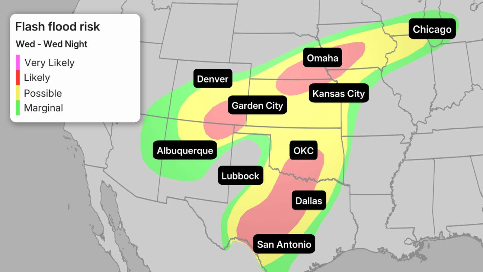
Wednesday’s threat: The threat of flooding shifts a bit eastward, with more of the threat expanding into Texas, Oklahoma and Colorado with pockets of locally higher flood threat noted in red, which include Oklahoma City and Omaha. There is even a chance of severe storms that could bring hail, winds and even an isolated tornado.
But tropical moisture will extend all the way into Wisconsin and Michigan, where there is a risk of flash flooding.
You can see the areas most at risk for flash flooding in the map below.
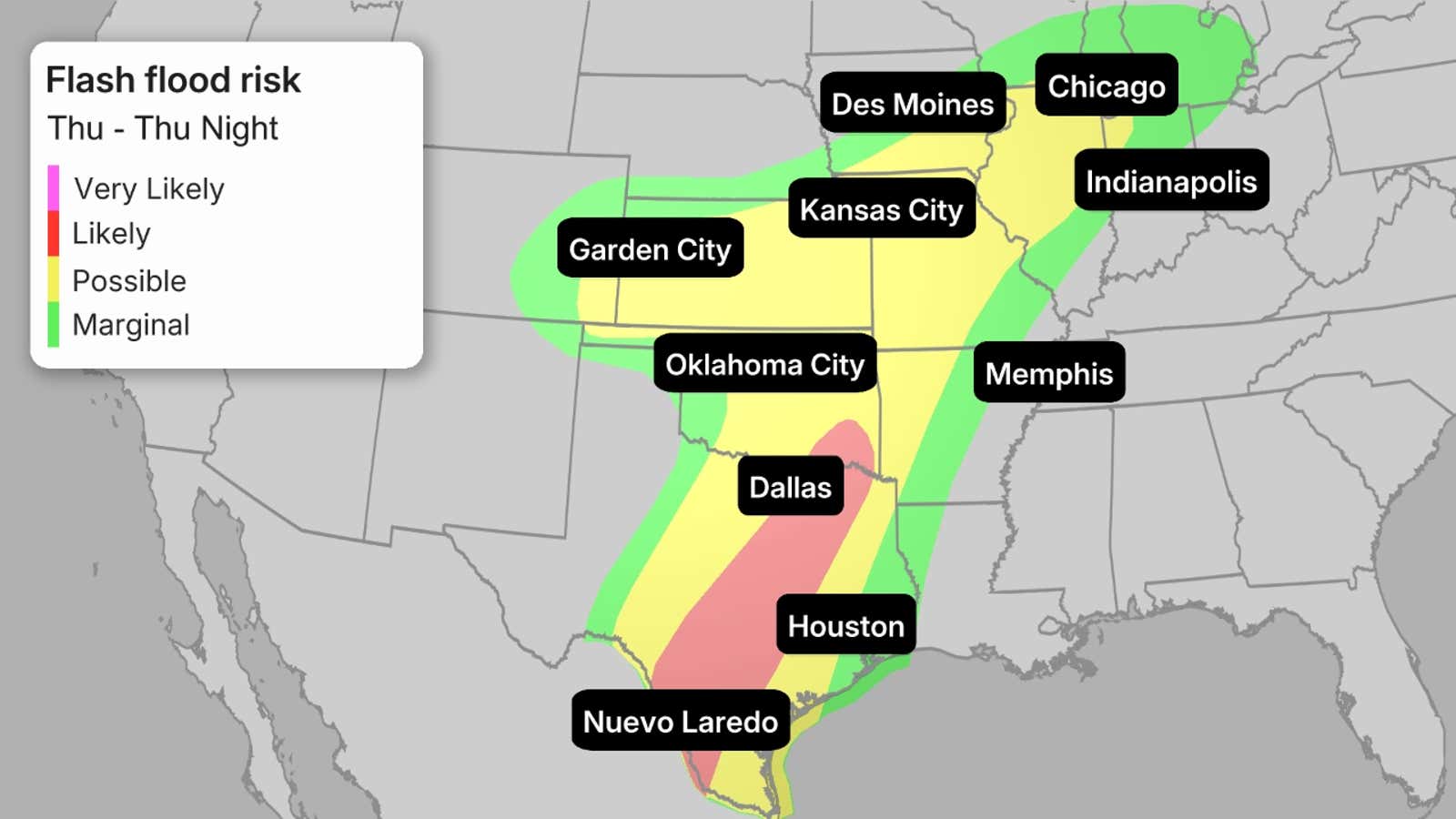
Thursday’s threat: The threat of flooding extends eastward to the Southern Plains and the Great Lakes, from Texas to Michigan. The heaviest threat of rainfall is again in place for a swath of Texas that includes Dallas and the Hill Country.
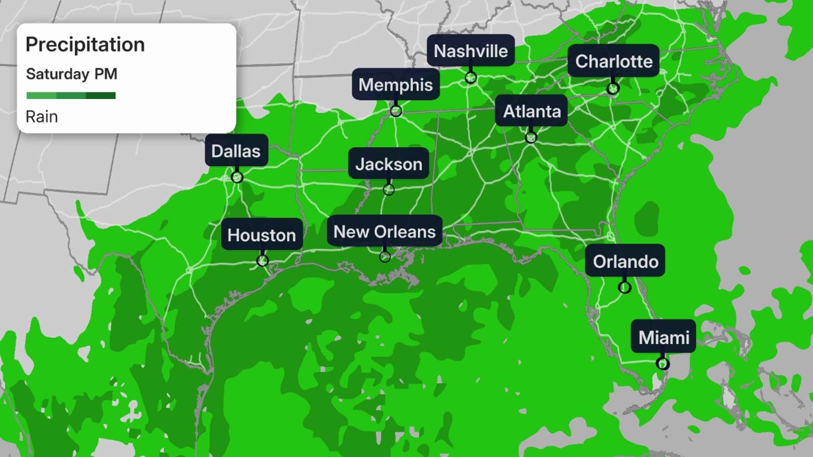
Weekend: By the time we get to the weekend, any organization of Polo will be long gone, but its moisture will still linger. The storm will get swept up in a cold front that will be driving to the east. Whatever is left of Polo will contribute to the active weather pattern across the East. The Southeast will get hit hardest with days of rain in the forecast.
How to stay safe during flash floods
When heavy rain threatens, never try to drive through a flooded road.
It may be tough to tell how deep the water is when you approach a flooded section of road, especially at night, so never try to proceed — instead, “Turn around. Don’t drown,” as the National Weather Service says.
Driving into a flooded area can allow water to stall or submerge your vehicle in a matter of minutes or even seconds.
Take warnings seriously. Your local National Weather Service office issues a flash flood warning when flash flooding is either already happening or expected to develop based on rainfall rates and radar trends.
You should make sure you are aware of possible flooding in your area when one is issued and avoid travel if possible, especially at night.
If a flash flood emergency is issued, that’s your signal that the situation is dire, and you should avoid travel and head to higher ground if in a flood-prone location.
(MORE: What to do before, during and after a flood)
Flooding Recap
On Monday, flooding swamped Casino Drive and the Laughlin River Walk beneath the Edgewater Casino in Laughlin, Nevada. One vehicle was also stuck in mud in the city about 75 miles south-southeast of Las Vegas.
Vehicles were flooded and stuck in Bullhead City, Arizona, Needles and Indio Hills, California.
A yard and basement were flooded in Hurricane, Utah, while a large cargo container was swept down the East Fork of the Virgin River and struck the US 89 bridge in Mt. Carmel, Utah.
Rainfall totals from Sept. 27 – 29 for part of the Southwest are between 1-3 inches. The highest total confirmed so far was a total of 3.91 inches in Bullhead City, Arizona. Albuquerque, New Mexico, saw over 2 inches so far and is approaching double the amount of rainfall it should see in the month of September.
Tuesday morning, a box truck was swept away by floodwaters north of Phoenix. The driver was able to make it out safely. At least one other water rescue was performed in the metro area for someone who thought they could drive through the water, but failed.
Several washes and even Interstate 10 saw flooding Tuesday between Tucson and Phoenix.
Flooding has also overwhelmed some roads in New Mexico where creeks and arroyos are running high already.
In addition to heavy rainfall and flooding, there were reports of winds exceeding 65 mph, and two tornado reports in northwest Texas on Tuesday evening.